Map settings: Setting a centre and zoom level for your map
This article is for Citizen Space Geospatial. Please speak to your customer success manager if you are interested in learning more about it.
In this article we’ll be discussing:
- What is the zoom and centre point used for?
- Setting your zoom and centre point
- Considerations for setting your zoom and centre point
- Disable the postcode search
What is the zoom and centre point used for?
Setting the centre point and a zoom level for your map enables you to control what the map will look like when it is on the survey page.
This means you can focus attention on a specific part of the map, whilst still enabling users to contextualise that location in the wider map area.
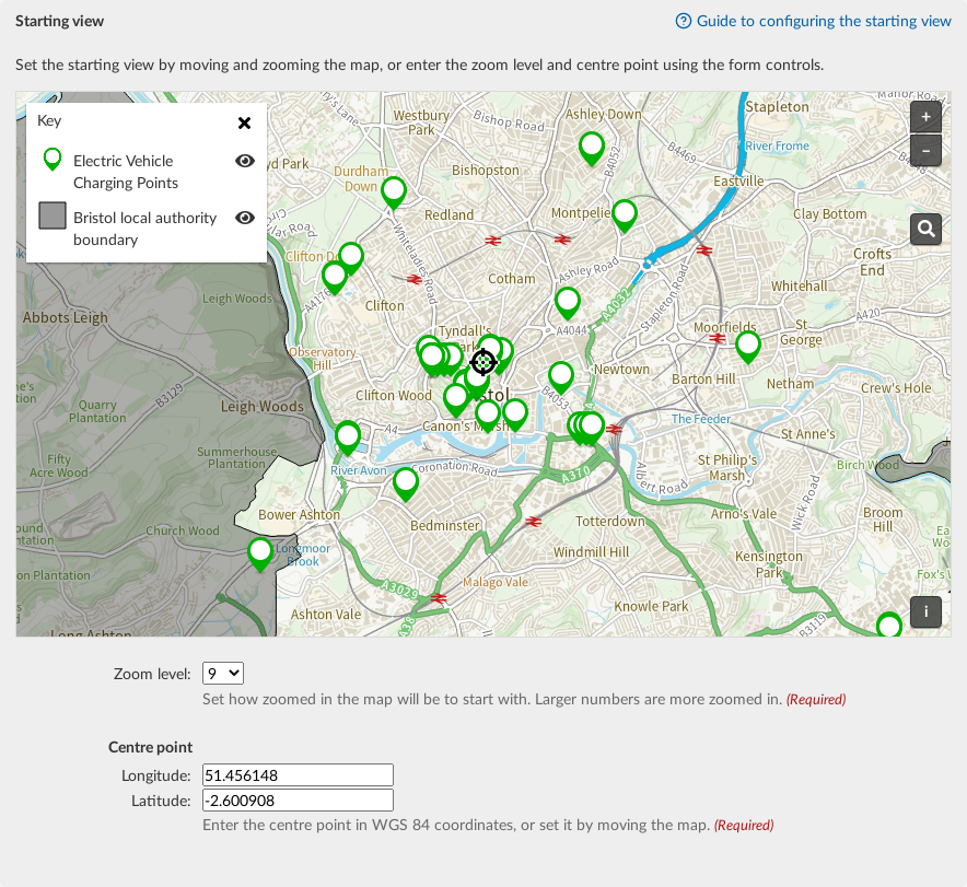
Setting your zoom and centre point
There is a default zoom and centre point (this is set by your main site admin) that you can change per mapping page if you wish.
You can set the zoom and centre point in two ways; via the map itself or via the form below the map. As you adjust one, the other will also adjust to reflect those changes.
To set your centre and zoom on the map:
- Search by postcode or select and drag the map so that the crosshair icon is on your chosen centre point.
- Zoom the map to the desired resolution.
- Select the Save Changes button.
To set your centre and zoom on the form:
- Chose the Zoom level from the drop down list. The larger the number, the more zoomed in the map will be.
- Enter the Longitude and Latitude of the centre point (this should be in WGS 84 coordinates).
- Select the Save Changes button.
Considerations for setting your zoom and centre point
- Think how this will appear on different sizes and shapes of screens, especially for those using mobile devices. You can use preview mode to see how it will look for respondents.
- Make sure you show enough of the map for people to easily understand the location. It is quicker for users to zoom in for more detail than to zoom out to understand the location, then zoom back in again for detail.
- If you want to have the same starting view on multiple maps, you can repeat the exact location by copying the Longitude and Latitude the and zoom level and then adding that information into another map.
Enabling or disabling the postcode search on maps
There is also the option to disable (or re-enable) the postcode search. This dropdown option sets whether you want show the postcode search tool on the map.
We recommend keeping the postcode search enabled. However, there are some territories and countries where the postcode search results are less reliable, and in those instances, disabling the postcode search would offer the best (and less frustrating) experience for respondents.